NE Oregon wildfire at nearly 11,000 acres; governor invokes Conflagration Act
(Update: With governor invoking Conflagration Act; update on fire in Tillamook State Forest)
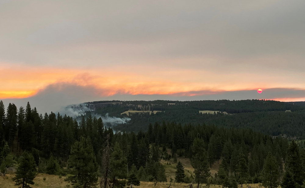
WALLOWA, Ore. - The nearly 11,000-acre Elbow Creek Fire in northeast Oregon continues to be pushed by erratic winds and hot temperatures, challenging firefighters as the fire burns primarily to the east and west, with some growth to the north, officials said Saturday as Gov. Kate Brown invoked the Conflagration Act to bring in more outside resources..
The fire is located in the Grande Ronde River drainage near Mud Springs, about 30 miles southeast of Walla Walla, Wash.
Here's the rest of Saturday morning's update from the Oregon Department of Forestry:
Helicopters and air tankers worked to slow the spread of the fire to the north and south yesterday, while crews aided in structure protection. Firefighters also worked the northwest side of the fire to keep the fire from spreading into Elbow Creek and progressing further through the Grande Ronde River drainage. Support from heavy airtankers aided in limiting the fire spread on the south on private ownership and firefighters were able to hold the fire last night north of Sickfoot Road.
Based on infrared mapping, the fire is estimated to be 10,941 acres in size, and remains at 0% containment.
Today, suppression activities are focused on holding the fire in the Wildcat Creek area on the east side and protecting structures at risk. Additionally, firefighters are establishing anchor points and scouting opportunities to build containment lines to the west side of the fire near Elbow Creek. Where terrain and fuels allow for crews to safely engage, firefighters continue working to build line construction and limit the fire spread on private ownership to the south, utilizing aircraft to slow fire spread.
The Elbow Creek Fire was reported on Thursday and is burning on both sides of the Grande Ronde River and is on or threatening Umatilla National Forest lands, Wallowa-Whitman National Forest lands, Vale District Bureau of Land Management lands and Oregon Department of Forestry-protected lands. The cause of the fire is under investigation.
Numerous resources are aiding in firefighting efforts, including landowners, private operators, and various federal and state resources (hand crews, dozers, multiple engines, and water tenders). The fire is currently being staffed by a Type 3 Northeast Oregon Interagency Management Team. The agencies will inbrief the Oregon Department of Forestry Team 3 Type 1 Incident Management Team led by Link Smith today at 5 p.m. at the Wallowa High School and the team is anticipated to take command of the fire tomorrow.
The conflagration request sent by Wallowa County Fire Defense Board Chief, Paul Karvoski, to the Governor’s Office has been approved and additional resources are en route to support structure protection work with suppression efforts. The Oregon State Fire Marshal’s Office is surging resources to assist the local fire agencies.
Wallowa County has updated evacuation information. Additional information regarding evacuations is available through the Wallowa County Sheriff’s Office at (541) 426-3131 or by monitoring the Wallowa County Sheriff’s Office on Facebook.
Closures are also in place surrounding the fire. Due to fire activity on both sides of the Grande Ronde River corridor, the river is closed at Minam State Park. Any rafters that arrive into the fire area will be safely evacuated in coordination with Wallowa County Search and Rescue. Due to extreme wildfire activity and the concern for the safety of the public the entirety of the Umatilla National Forest has been temporarily closed.
Hot and dry conditions are expected to persist throughout the week. Fire officials want to remind everyone that the current fire danger rating remains at EXTREME.
The latest fire information can be found by visiting the Blue Mountains Fire Information Blog
(http://bluemountainfireinfo.blogspot.com/).
Governor Kate Brown Invokes the Emergency Conflagration Act in Response to the Elbow Creek Fire
Elbow Creek Fire is burning 10,940 acres in Wallowa County
(Salem, OR) — Governor Kate Brown invoked the Emergency Conflagration Act yesterday in response to the Elbow Creek Fire that broke out in Wallowa County Friday morning. The fire is estimated to be 10,940 acres in size and is located near Troy, where there are Level 3 evacuations in place. An Office of the State Fire Marshal Incident Management Team will be briefed today, will be in unified command with Incident Management Teams already in place, and will work to bring resources from counties around Oregon to assist in the response.
"With fires burning around the state and continued dry weather, I want to remind all Oregonians to be extremely cautious with any activities that could spark fires," said Governor Brown. "I also want to urge Oregonians to make sure they and their families are safe by being prepared to respond to wildfires. Preparedness is more important than ever as fire seasons continue to start earlier and last longer."
In accordance with ORS 476.510-476.610, Governor Brown determined that a threat to life, safety, and property exist due to the fire, and the threat exceeds the firefighting capabilities of local firefighting personnel and equipment. The Governor's declaration cleared the way for the State Fire Marshal to mobilize firefighters and equipment to assist local resources battling the fire.
The Office of the State Marshal's Blue Incident Management Team has been mobilized. OSFM personnel responded with a Communications Unit and a cache trailer loaded with incident support supplies, tools to enhance defensible space around structures, and other provisions firefighters need to inhabit a fire camp.
Additional updates for the incident may be accessed at:
- Oregon State Fire Marshal Facebook Page
- Oregon Department of Forestry Facebook Page
- Wallowa-Whitman National Forest Facebook Page
Information on wildfire prevention and preparedness may be accessed at:
GAME HOG CREEK FIRE REMAINS AT ABOUT 135 ACRES IN TILLAMOOK STATE FOREST
News Release from Oregon Dept. of Forestry
Posted on FlashAlert: July 17th, 2021 12:34 PM
FOREST GROVE, Ore. – Mechanical issues grounded two helicopters before they could assist at the Game Creek Hog Fire. Instead, ODF’s The Dalles Unit loaned two single-engine airtankers to the fire team engaged on the fire. Today, both planes are scooping water up from Hagg Lake and dropping it onto hot spots in the steep terrain of the Elk Creek drainage where the blaze is located. The fire remains entirely within the Tillamook State Forest.
Arrival of an additional hand crew has increased personnel engaged on the fire to about 100. The fire has so far been kept to about 135 acres of the 364,000-acre state forest.
The Tillamook State Forest remains open but visitors can expect smoke in the area. However, the Drift Creek and Idiot Creek forest roads and the Fear and Loaming mountain bike trail remain closed due to fire activity. Also closed is Rogers Camp trailhead, which is being used as a staging area for firefighters. Highway 6 and 26 to the coast remain open and unaffected by the fire, which is burning about two miles north of Highway 6. No evacuations are associated with this fire.
Cause of the fire is still under investigation.