Burning Man "needed urban design because it's a city" says founder Larry Harvey
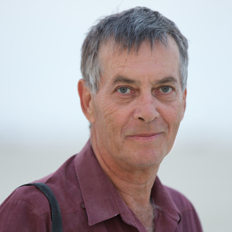
Later this week, 70,000 people will converge on a temporary city in the Black Rock Desert, Nevada. Burning Man founder Larry Harvey told Dezeen about the "stunning achievement" of creating a high-density, car-free festival in a remote and inhospitable landscape (+ slideshow + transcript).
In the early years the Burning Man festival had few rules, but as the event grew in scale, Harvey realised the anarchy needed to be replaced by a degree of order.
"People craved orientation," he said during a phone interview with Dezeen, set up after a meeting at Design Indaba in Cape Town earlier this year, where Harvey was a speaker. "It was a very basic primal need."
As a result the organisers realised they had to act as a "de facto government" of this huge temporary settlement, which came to be known as Black Rock City.
Harvey, born in 1948, worked with late architect and urban designer Rod Garrett to perfect the festival's layout. "We needed urban design because it's a city," said Harvey, who started the festival on a San Francisco beach in 1986 before moving it to the vast, featureless desert, which is "the size of a small European country," in 1991.
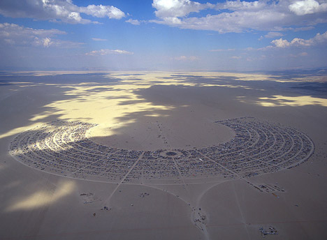
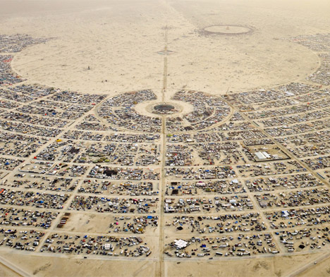
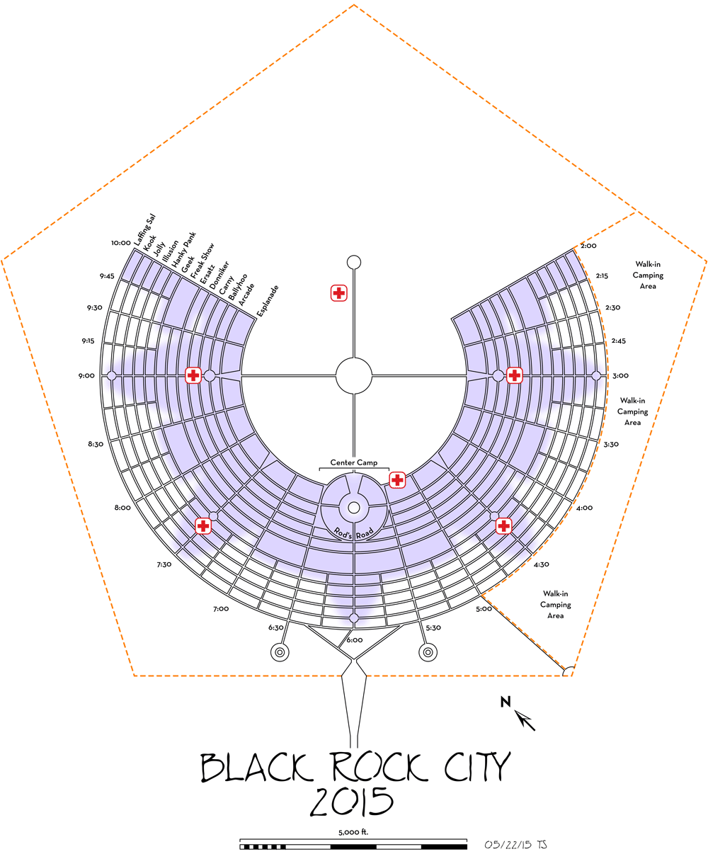
Black Rock City is laid out in a horseshoe around the "burning man" – a giant effigy that is set alight at the climax of the festival. This layout evolved over many years to help attendees orient themselves and ensure their safety, but also to "induce social interactions that would in turn generate a sense of community and a culture," Harvey explained.
Harvey is particularly proud of the fact that Burning Man, which this year runs from 30 August to 7 September, achieves high densities and low car use in a country where most cities are sprawling and car dependent.
"It's a stunning achievement and people just take it for granted," he said. "We're building in densities that Americans aren't used to."
"It is pretty dense and we liked that because we were obsessed with constructing social interaction, so we engineered those densities to promote that."
Cars, which were previously driven with abandon, were banned from the festival's streets after a serious accident in 1996, but this led to the widespread adoption of bicycles.
"And the bicycle thing, well since people couldn't use their cars they had to use their bicycles didn't they?"
Read an edited transcript of the interview with Larry Harvey below:
Marcus Fairs: Tell me how the layout of Burning Man evolved. Why did you need to work with an urban designer?
Larry Harvey: Well, we needed urban design because it's a city. The contemporary form of it evolved by stages. Actually, in the very beginning there was a design that no one had actually consciously considered but just emerged as a response to the space. We were a small little band in all that emptiness, and like any group we sort of gathered around a centre and created a sense of shelter in the midst of this vacuum that had otherwise threatened to swallow us up.
One of the most significant discoveries was that we discovered the power of surveyors flags. We discovered that you could delineate boundary lines at any scale you pleased as long as people could see the line created by a succession of flags. Therefore you could craft space in an environment that was so disjointed.
People craved orientation. It was a very basic primal need. So we could create a boundary that served lots of functional purposes and especially create boundaries that people would camp along. Eventually that was the way we created everything: the streets, every aspect of the bounded environment.
It was not unlike the Greeks when they'd go about creating new cities. I may be wrong about this but I think there was a Greek god of boundaries that they would honour to begin with, and that's kind of what we were doing. We thought we were Greeks.
Marcus Fairs: And when you started using those flags did you already have the horseshoe layout?
Larry Harvey: Well, no. It was informal, so the first few years there remained some kind of central point where there might be some shade, and people camped in an immediate circle around it. Beyond that it was just random. But that initial cue was enough to create a centre and the city just dispersed outwards. So the first street was a circle around the civic centre.
From that we configured the city as a compass with north, south, east and west indicators and that was again because of the vastness of the space. It was very easy to get disoriented. We were very small but even at any scale if you get very far from a point of reference it sort of dissolves in the thermals and things can get very disorienting. One side of the valley looks like another if you're not paying attention to the stars or the moon at night. It's just an oceanic chaos. So we constituted that as a device, as a compass that would orient people.
All of that developed in reaction to this boundless space. It's hard to describe the power of it. It's so supremely featureless, you know. There's no life there to interrupt; the alkaline sediments are inimical to most forms of life. I think there's one species that can live there, a tiny shrimp, and that's one tiny little species in an area the size of a small European country.
So all of that was an attempt to construct a comprehensible space and indeed, from the very beginning, it was a life or death issue. It was an existential issue because people could easily overshoot our campsite. The original means to guide people there, before we had a gate and were able to charge for admission, was that we'd direct them to a place where they could exit a highway.
There they would find a trailer where they would be given the secret instructions to travel so far north and then so far east. And if they were lucky they found us. And then what they would find is what amounted to a giant compass inscribed on the desert floor just by using these flags.
So that gets to the point where you have the cardinal directions and you have a circle in the centre. I'll fast forward a bit. When we moved location in '96, when 10,000 people came, it became clear that we were a de facto government, inscribing these diagrams on the desert floor.
We formed a police force because people would get lost and we wanted to save their lives; there were people who patrolled the outer bounds of the desert looking for castaways and strays who would get easily mired, since the desert has a very high water table and they'd sink to their axles and be stranded.
Over the years many have people died in the desert and no one regularly patrolled it, the local county didn't send people out. After '96 it became very plain that unless things were regulated, unless we could create civic order, with the numbers that were coming in, it was unsafe. No longer could it be regarded as a shooting range, no longer could automobiles be given license to drive at random around the encampment, sometimes with their lights turned off, sometimes driving at 100 miles an hour.
In fact what became apparent is that all this confusion was limiting people's liberty, because if you live in fear, you are not free. So we left the desert and went to a nearby property in Hualapai valley, which is only about a twenty minute drive from Black Rock, and that's where we have our production facility and our ranch today.
What we liked about that site is that on all sides there was a natural boundary to entry, which allowed us to set up a gate. That gave us an income.
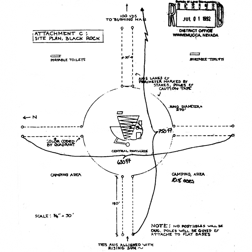
We occupied an area of a tiny playa [dry lakebed] not much bigger than an acre, maybe less. It was federal land and we didn't have a permit [to camp on the playa] so we placed the man in this small playa in a more or less central location.
There was a vegetated portion of land that bordered the little playa and we made a campground on that. This was a matter of political accommodation because we were trying to get out of the federal jurisdiction. So we created a city, a settlement, on the land that fronted that playa.
It was an awkward, segmented thing. The plan was crisp but the execution was… well, it was vegetated land so the roads that we made were not entirely regular. But the diagram, the map, formed the basis of the contemporary Burning Man.
Marcus Fairs: So you took this design with you when you returned to the Black Rock Desert in 1997?
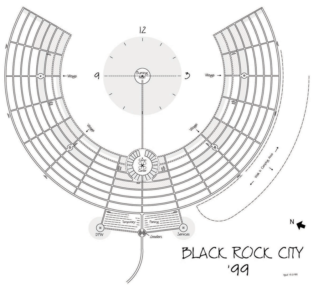
Larry Harvey: So we took what had been created, this idea of the man, which echoed the very beginning when the man was apart from the settlement, and somehow we retained that, and this awkwardly segmented city that curved round it, in some recipient way became this semi-circle. We replicated that and figured out a way to create a boundary around it that was patrolable, which we didn't have the means to do before.
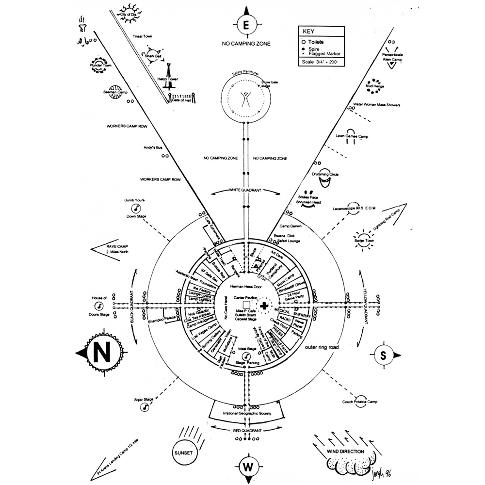
But finally we met this new challenge – and this was all to deal with traffic – and secured a border, which had a great influence on everything thereafter. And then we turned the city into an arc and so located the man – and this was a brilliant stroke – so that it became a common survey point for everything, which means literally that every dimension derives from that unique spot. You couldn't do that if it were a rectilinear grid, but it was a perfect segmented arc and it worked beautifully for that. In turn that affected people's experience greatly because it became the ultimate landmark for where you were. You'd look to see the location of the man.
1997 was an inspiring year, we made a lot of innovations. It seems obvious now but it wasn't then that if you treat it like a clock face then everyone knows how to read a clock face. Then if you named the radial streets after the hours, and then alphabetised the latitudinal streets that follow the curve, then the coordinates are very simple and you can find everything.
Everything since then was an elaboration of this central design. It allowed us to grow: we just added streets at the back. We tried experiments later by blowing it up or shrinking it down, increasing the volume of things, and that was interesting. But we never departed them from that very basic design because it worked so well on so many levels.
It was very practical. It made it easy to set the city up. It made it easy to navigate the city. It was very easy to orient oneself in relation to everything within the pentagram that was our outer boundary of the municipal space. That was a five-sided figure because it was Rod [Garrett]'s calculation that it was the most patrolable shape. A circle wouldn't have done, but if you have a five-sided figure and you post people at the points, you could survey the entire boundary line.
So with that five-sided figure and the segmented arc and the central location of the man, which also served as the place from which the entire city was surveyed and measured, you had essentially what we have today.
We added some things as we went along. We wanted to socialise people and promote interaction and foment neighbourhoods. We created courtyards – plazas – that ran along the six o'clock, three o'clock and nine o'clock axes. And that pretty much accounts for the design of the city.

Marcus Fairs: At what point did you decide that you needed to bring an architect or a designer on board? How did the collaboration with Rod Garrett come about?
Larry Harvey: Well that started in 1997. [Rod] was the landlord of two of my colleagues, and once I got to know him I came to collaborate with him on a lot of things; not only designing the city but we had a very close creative collaboration in designing the themes every year, the architectural aspects. I would invent the theme and then we would work together to find means of expressing it. He would design the man bases as we call them, because they function as pavilions rather than just as pedestals [of the central effigy] and he would design those. We would go back and forth together, which was lovely.
I soon came to realise he was a genius. He could see things in three dimensions in his mind and produce designs with remarkable clarity. So he was very talented and as geniuses do was able to focus his attention on any design question so considerably that he could find solutions, elegant and organic solutions to problems much faster than most people can.
And you know, it wasn't just Rod dreaming something up in a fit of utopian enthusiasm. It was us talking to him incessantly about the practical needs and myself talking to him about the symbolic needs. He was an intuitive man, he was an artist.
Marcus Fairs: The radial, arcing layout has been compared to garden cities and utopian cities. Were you aware of that at the time or was it just the most practical solution to the needs and the site?
Larry Harvey: It was just the solution to the problems that we had. It was partly visionary and also highly rational. But the impetus was very pragmatic: we'll do what works. Our preoccupation has always been to craft space in such a way as to induce social interactions that would in turn generate a sense of community and a culture, but starting from the very immediate issue of how action influences perception.
Rod and I were very much in the same mind in that regard, so it wasn't as though we were crafting it to represent something, although we were crafting it in a way as to induce certain very basic primal impressions. So I started out talking about primal impressions and adaptions to this existential challenge. We always maintain that view of it, except our aims became more and more sophisticated as our notion of what the civilised ends we wanted to achieve became more clear to us.
Marcus Fairs: Do you think Burning Man has any lessons for permanent cities?
Larry Harvey: No, we never thought of it that way frankly. You could extend it but at a certain point that it would become impractical if you just kept scaling that up and turned it into a city of a million people. The design wouldn't work. For ceremonial purposes it could even go larger; we think it could go up to 100,000 people. I'm just talking about the city design, not necessarily the logistical problem of people getting to and from it. But for ceremonial purposes it's absolutely sublime.
Marcus Fairs: And it also looks a little bit like an amphitheatre as well; a flattened amphitheatre.
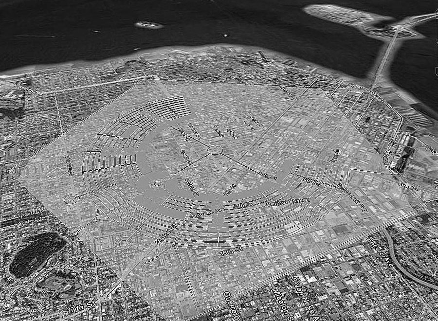
Larry Harvey: Yeah, and it looks like a Neolithic temple complex. There are a couple I know that are remarkably like that. I've actually looked at aerial photographs of one and it looks like it could almost be our city. But we were not aware of that as we went along. We were engineering society but we weren't basing it on some elaborate intellectual construct. You know, that way of looking at it, which is what I'm dishing out here because I'm meditating on our actions, it doesn't work the other way round. We're not French.
Marcus Fairs: A city without cars is pretty unusual in America. Do people immediately adapt to the pedestrian life or the cycling life?
Larry Harvey: Well I'm glad you mention that, because it's a stunning achievement and people just take it for granted. It's true at campsites in America: you're not allowed to drive. Well, some of them are overrun with various roads because people can't be bothered with hiking to a trailhead, but the recognised pattern is that you park your car by your campsite. It's not like a city where everything is laid out for the convenience of travel by automobile.
But we did it just to preserve life. There was a terrible accident in '96 and that made a great impression on everybody, so that was our incentive for doing that. We did two things: not only did we require people to anchor their cars to their campsite but eventually, as time went on and we were placing more and more camps ahead of time – that is, allotting them space – we were building in densities that Americans aren't used to. It was pretty dense and we liked that because we were obsessed with constructing social interaction, so we engineered those densities to promote that.
Obviously the problem with people being in their cars is that they were just threats to one another. But suddenly as soon as we began zoning and placing some camps in '97, whole villages rose up almost overnight, which in the old pattern was a scattershot thing, where there was no latitude and the organisation of the space did not conduce to that.
It was libertarian but it was highly communitarian. People still had the open playa where all the art is and they can course about and, except for the two axes, trackless. You have complete freedom of movement so it's a nice contrast. You have this sandbox, this arena of freedom and radically free life, and then you have this more or less stamped grid that is, at least by American standards, very dense. It's packed together.
And the bicycle thing, well since people couldn't use their cars they had to use their bicycles didn't they? Or else they could turn cars into art, which is quite an enterprise and our standard for that has got higher and higher and higher as people have excelled at creating things, so now that's a rather high standard and it's a real commitment and it is an informal public transportation system but we didn't really see it that way.
So the art cars are the public transportation system. And that requires regulation because lately we've had art cars that don't want people on board and that want private parties, and that's in conflict with the communitarian feeling and the interactive aspect of society. So now we're moving to shift opinion and affect behaviour, so they will be accepting of all citizens.
Images and plans courtesy of the Burning Man festival and Jonathan LaLiberty.