Your search for images, in grid reference SP0013, in reverse Date Submitted order, returns
61 images:
( Page 1 2 3 4 5 next >> last ) [refine search]
[quick refine]
|
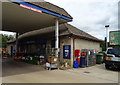
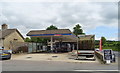
Service station and Post Office, on the A435, Colesbourne
by JThomas geograph for square SP0013 Tags: [top:Business, Retail, Services] [top:Communications] [Elizabeth II postbox] [type:Geograph] [Post box] [Postbox] Showing position of Postbox No. GL53 147.
See SP0013 : Elizabeth II postbox on the A435, Colesbourne for postbox.
|
|
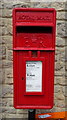
Elizabeth II postbox on the A435, Colesbourne
by JThomas for square SP0013 Tags: [top:Business, Retail, Services] [top:Communications] [type:Close Look] [Elizabeth II postbox] [Post box] [Postbox] At the service station and Post Office.
Postbox No. GL53 147.
See SP0013 : Service station and Post Office, on the A435, Colesbourne for context.
|
|
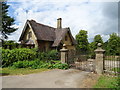
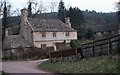
The Lodge to Colesbourne Park
by JThomas geograph for square SP0013 Tags: [top:Housing, Dwellings] [type:Geograph] On the A435.
|
|
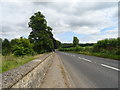
A435, Colesbourne
by JThomas geograph for square SP0013 Tags: [top:Roads, Road transport] [type:Geograph] Towards Cirencester.
|
|
Service station on the A435, Colesbourne
by JThomas geograph for square SP0013 Tags: [top:Business, Retail, Services] [type:Geograph] |
|
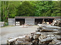
Colesbourne Saw Mill
by Rod Allday geograph for square SP0013 Tags: [top:Business, Retail, Services] [top:Lowlands] [top:Village, Rural settlement] [type:Geograph] [subject:sawmill] |
|
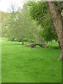
Bridge over the River Churn at Colesbourne
by Rod Allday geograph for square SP0013 Tags: [top:Country estates] [top:Grassland] [top:Lowlands] [top:Rivers, Streams, Drainage] [subject:bridge] [type:Geograph] |
|
Little Colesbourne - Withington, Gloucestershire
by Martin Richard Phelan geograph for square SP0013 Tags: [top:Farm, Fishery, Market Gardening] [top:Grassland] [top:Housing, Dwellings] [top:Lowlands] [top:Roads, Road transport] [top:Village, Rural settlement] [17th/19th century building] [area:Cotswold District] [subject:farmhouse] [type:Geograph] [area:Gloucestershire] [area:Gloucestershire Cotswolds] [Grade II listed building] [place:Little Colesbourne] [place:Withington] This is the detached farmhouse of Little Colesbourne which in spite of its name is actually in the parish of Withington. It was Grade II listed on 11th February 1986 and... (more)
|
|
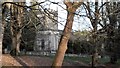
St James' church in Colesbourne Park
by Chris Brown geograph for square SP0013 Tags: [top:Park and Public Gardens] [top:Religious sites] [top:Village, Rural settlement] [type:Geograph] For a Cotswold valley, the upper Churn has an unusual concentration of parks and mansions enlarged in the 19th century. Colesbourne is an estate village with the church... (more)
|
|
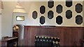
St James' church, Colesbourne: chancel
by Chris Brown for square SP0013 Tags: [top:Religious sites] [top:Village, Rural settlement] [type:Close Look] [type:Inside] Looking through the full-height squint into the north transept. The bronze tablets commemorate members of the Elwes family of Colesbourne Park. Part of the timber... (more)
|
|
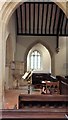
St James' church, Colesbourne
by Chris Brown for square SP0013 Tags: [top:Religious sites] [top:Village, Rural settlement] [type:Inside] View from the north transept across the nave to the south transept, with the wineglass pulpit by the chancel arch.
|
|
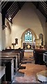
St James' church, Colesbourne
by Chris Brown for square SP0013 Tags: [top:Religious sites] [top:Village, Rural settlement] [type:Inside] Largely rebuilt in 1851-2 to designs of David Brandon. The small size of the chancel arch is a clue to older origins.
|
|
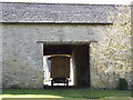
Shepherds hut
by norman hyett for square SP0013 Tags: [top:Country estates] [top:Farm, Fishery, Market Gardening] [top:Village, Rural settlement] [type:Close Look] |
|
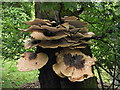
A fungi feast
by norman hyett for square SP0013 Tags: [top:Village, Rural settlement] [top:Wild Animals, Plants and Mushrooms] [type:Close Look] Sadly Fungi and tree no longer here.
|
|
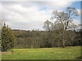
Churn valley
by Derek Harper geograph for square SP0013 Tags: [top:Farm, Fishery, Market Gardening] [top:Lowlands] [top:Woodland, Forest] [pasture] [fence:timber] [Tree] [valley] [wood] From beside the junction shown in SP0013 : Junction at Colesbourne. The Churn at this point has just been joined by the Hilcot Brook, a substantial tributary. The wood behind is Hippetts Grove.
|
Search took 0.00 secs, ( Page 1 2 3 4 5 next >> last ) [refine search]
View/Download: KML geo RSS GPX Try opening in Browser function (Experimental, may not work!)Found these results useful? Please Donate
|