


A recent trend of wintery weather hitting Colorado is set to continue, with more snow on the way that may serve as a prelude to what's to come.
According to a map released by the National Weather Service on Wednesday, up to 18 inches of snow is expected on some Colorado peaks from December 7 through the morning of December 9. And remember, the same forecasting service had previously predicted a slight 'risk of heavy snow' from December 9 to December 11 earlier this week.
With this first round of snow, most high-elevation parts of the state should see accumulation in the range of 12 to 18 inches, with about three to four inches expected in Denver and Colorado Springs. Most Front Range cities should get a few inches.

The 'most likely' snowfall scenario. See probabilities of six inches or more in article below. Map: National Weather Service.
A lot of this heavy snow is expected to fall along the I-70 corridor, so travel delays are something to keep in mind for those crossing the state during this period.
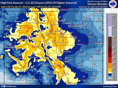
It's also worth noting that the 'high-end' forecast (seen as feature image at the top of this article) calls for big totals to be much more widespread over upcoming days. In that scenario, Denver and Boulder get seven inches, Castle Rock gets nine, and Colorado Springs gets six. This would likely make travel dicey along the I-25 corridor.
Chances of this high-end scenario taking place aren't incredibly slim, with a 20 percent chance that Denver gets six inches or more of snow, a 52 percent chance that Castle Rock gets six inches of snow or more, and a 16 percent chance that Colorado Springs gets six inches of snow or more.

The chances of at least six inches of snow. Map: National Weather Service.
The National Weather Service also published a 'low end' snowfall forecast, which has a 10 percent chance of taking place. If this 'low end' accumulation occurs, totals in the mountains max out between six and eight inches, with only a couple inches of snow for most of the Front Range.
Whether or not another storm will follow over the weekend remains to be determined. On December 4, an experimental 'risk of heavy snow' map published by the National Weather Service noted the potential for another storm to roll through from December 9 to December 11. That being said, the chances of this storm may have since dropped or shifted forward, as forecasting services like OpenSnow and Mountain-Forecast.com don't show big totals during these dates at this time. For examples, Mountain-Forecast.com is calling for a couple inches on some Colorado peaks on Sunday, but not totals that would be worthy of a headline.
Either way, it's important to be prepared for the snow that is officially on the radar. Pack your truck with essential safety items, like kitty litter, extra blankets, and water.


(0) comments
Welcome to the discussion.
Log In
Keep it Clean. Please avoid obscene, vulgar, lewd, racist or sexually-oriented language.
PLEASE TURN OFF YOUR CAPS LOCK.
Don't Threaten. Threats of harming another person will not be tolerated.
Be Truthful. Don't knowingly lie about anyone or anything.
Be Nice. No racism, sexism or any sort of -ism that is degrading to another person.
Be Proactive. Use the 'Report' link on each comment to let us know of abusive posts.
Share with Us. We'd love to hear eyewitness accounts, the history behind an article.