At a Glance
- The East will see the highest chances for warmer-than-average temperatures early in the summer.
- Temperatures are expected to be well-above average in parts of the West mid-to-late summer.
- Cooler-than-average temperatures are possible in portions of the northern tier.
Warm temperatures are expected across much of the U.S. this summer, especially in portions of the South and West, according to the latest outlook from The Weather Company, an IBM Business.
These warmer-than-average conditions include the Pacific Northwest, where a chilly pattern has been in place throughout much of the winter and into the beginning of spring.
(MAPS: Weekly Planner and 30- and 90-Day Outlooks)
The recent trend of above-average temperatures is also expected to prevail in the Southeast. Areas near the Great Lakes may see overall cooler-than-average conditions during the June through August period.
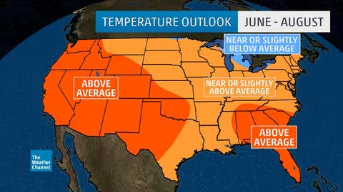
"Typical transitions from La Niña to El Niño conditions result in cooler summers overall, especially late; our forecast reflects this warmest-early, coolest-late idea, but is not particularly cool given the recent pronounced global-scale warming," said Dr. Todd Crawford, chief meteorologist with The Weather Company.
In the most recent outlook, NOAA placed the odds of El Niño developing from about August to December at 50 percent. El Niño is the warming of the equatorial eastern and central Pacific Ocean temperatures, which can have impacts on weather patterns across the globe.
(MORE: El Niño May Develop in Late 2017)
Even though there are questions about whether El Niño will develop or not, the influence of La Niña on the atmosphere is expected to wane heading into summer, says Crawford, This will help temperatures in the Northwest to gradually evolve toward above average instead of the below-average conditions recently experienced.
Below we take a closer look at what is expected each month.
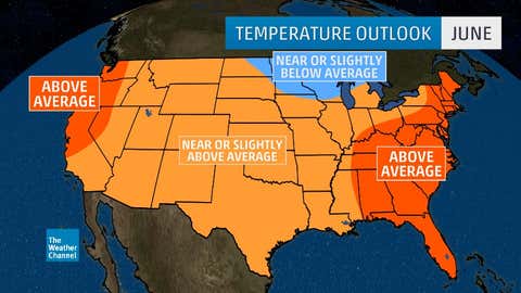
June
The greatest chance for warmer-than-average temperatures this summer for the Northeast will be in June. Above-average temperatures are also likely in the Southeast, as well as for much of the West.
(MAPS: Average Monthly Temperatures)
The area that could see cooler conditions will be in parts of the Upper Midwest and Great Lakes region. Much of the Plains and Rockies, will see temperatures near to slightly above average.
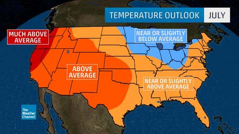
July
In July, temperatures are expected to be well above average from northern California into western Washington, the opposite of what occurred this winter. The rest of the West, with the exception of Montana, will also see warmer-than-average temperatures.
(MORE: Here's When You Can Expect Your First 80- and 90-Degree Temperatures)
A different story is expected farther east, where cooler-than-average temperatures will stretch from the Upper Midwest into the Ohio Valley and the eastern Great Lakes. Temperatures for the Southeast will likely be near to slightly above average.
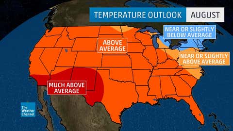
August
The expanse of hotter-than-average temperatures will grow in August, stretching from the West coast through the Plains and into parts of the Midwest and Southeast. The area from southern California into New Mexico and western Texas may see temperatures soar well above average.
(MORE: 2017 Atlantic Hurricane Season Forecast)
Most of the Northeast, however, will likely experience near-to-slightly-below average temperatures. Temperatures in the mid-Atlantic and eastern Great Lakes will generally be near to slightly above average for the last month of summer.
It is important to remember that this is an overall trend for the three-month period June-August. An individual southward dip in the jet stream or an upper-level ridge of high pressure could lead to a brief period of colder or warm weather, respectively.
MORE ON WEATHER.COM: Atlantic Basin Retired Hurricanes and Tropical Storms (PHOTOS)