Kona Low drenches Hawaii with heavy rain triggering flooding, emergency proclamation
The Kona Low was swirling about 600 miles north of the islands on Thursday and is forecast to meander in the region, pulling deep tropical moisture over the islands and triggering a dayslong flooding threat.

More rain for already flooded Hawaii
FOX Weather is tracking a Kona Low that is dumping inches of rain on Hawaii flooding homes and washing out roads. How long will it stick around?
HONOLULU—A Kona Low has halted Hawaii’s renowned sunshine through the weekend, drenching the tropical paradise with prolonged heavy showers and thunderstorms. The storm system threatened flash flooding, leading to an emergency declaration from the state.
"The (forecast) model guidance for this week looks anything typical of mid-May for Hawaii, to say the least," forecasters with the National Weather Service in Honolulu wrote in their forecast discussion earlier this week.
Satellite and local radar imagery continue to show a large band of moderate to heavy showers currently over Oahu. The Kona Low is forecast to meander in the region through the weekend.
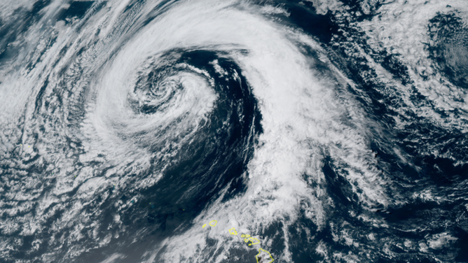
Satellite imagery shows a Kona Low to the north of Hawaii on May 16, 2024.
(CIRA / RAAM-B / NOAA)
"Kona" comes from the Hawaiian word for "leeward" – the side sheltered from the typical northeasterly trade winds.
Kona Lows are problematic as the winds reverse from the typical trade winds, bringing heavy rain to what are normally the wind- and rain-shadowed leeward areas of the islands. That will be the case here. While this Kona Low will be perched several hundred miles away from the islands, it has switched the winds to the south.
Meanwhile, a large area of deep, tropical moisture sits just south of the islands, providing the Kona Low with ample nearby fuel to pull over Hawaii and enhance rainfall. Dew points have been around or over 70 degrees since Wednesday in Honolulu and Lihue, indicating plenty of tropical moisture available.
The combination brought potential for prolonged periods of heavy rain and thunderstorms through at least the end of the week, prompting Hawaii Gov. Josh Green to sign an Emergency Proclamation.
"We are taking our preparedness seriously," Gov. Green posted on X. "The National Guard is on hand to respond swiftly and effectively to any emergencies that arise from the Kona Low storm conditions."
![Hawaii Flooding]() Image 1 of 10
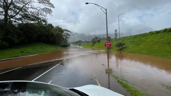
Image 1 of 10Flash flooding on Oahu during heavy rain on May 13, 2024. (Hawaii Dept. of Transportation)
![Flooding and mudslides in Hawaii]() Image 2 of 10
Image 2 of 10Flooding and mudslides occur in Oahu on May 13, 2024. (Hawaii Dept. of Transportation)
![Flooding and mudslides in Hawaii]() Image 3 of 10
Image 3 of 10Flooding and mudslides occur in Oahu on May 13, 2024. (Hawaii Dept. of Transportation)
![Flooding and mudslides in Hawaii]() Image 4 of 10
Image 4 of 10Flooding and mudslides occur in Oahu on May 13, 2024. (Hawaii Dept. of Transportation)
![Flooding and mudslides in Hawaii]() Image 5 of 10
Image 5 of 10Flooding and mudslides occur in Oahu on May 13, 2024. (Hawaii Dept. of Transportation)
![Flooding and mudslides in Hawaii]() Image 6 of 10
Image 6 of 10Flooding and mudslides occur in Oahu on May 13, 2024. (Hawaii Dept. of Transportation)
![Flooding and mudslides in Hawaii]() Image 7 of 10
Image 7 of 10Flooding and mudslides occur in Oahu on May 13, 2024. (Hawaii Dept. of Transportation)
![Flooding and mudslides in Hawaii]() Image 8 of 10
Image 8 of 10Flooding and mudslides occur in Oahu on May 13, 2024. (Hawaii Dept. of Transportation)
![Flooding and mudslides in Hawaii]() Image 9 of 10
Image 9 of 10Flooding and mudslides occur in Oahu on May 13, 2024. (Hawaii Dept. of Transportation)
![Flooding and mudslides in Hawaii]() Image 10 of 10
Image 10 of 10A mudslide partially blocks the Kalanianaole Hwy at milepost 61 on Oahu during heavy rains on May 13, 2024. (Hawaii Dept. of Transportation)


The NWS warned that significant flooding may occur from the overflow of streams and drainage pipes. Runoff may also cause property damage in urban areas.
"Landslides may also occur in areas with steep terrain," the NWS said.
Nearly a foot of rain in some spots leading up to Kona Low
It’s already been a very wet week for Hawaii. Flood Watches and Warnings were posted across the islands last weekend as a slow-moving storm system scraped the islands, with even winter storm conditions atop the Big Island’s mountain peaks.
The Hawaii Department of Transportation's social media feeds have been full of photos showing various mudslides and flooded roads around the state while announcing multiple weather-related temporary road closures.

(FOX Weather)
Even on Monday ahead of the Kona Low, Flash Flood Warnings were in effect for eastern Oahu as a strong thunderstorm brought rainfall rates of 2 inches per hour, causing some localized flooding.
Several rain gauges in the higher elevations of Oahu have reported over 8 inches in the past 72 hours, with a gauge at St. Stephens Seminary near Kailua receiving over 18 inches of rain in three days.
A gauge in Kaneohe had over 9 inches in 72 hours, while the Marine Corps base at Kaneohe reported 5.01 inches for the same period.