Multiple days of severe weather threaten Plains, Midwest beginning Sunday
May is typically the month with the greatest amount of tornadoes across the country. According to Storm Prediction Center data, between 250 to 300 twisters form every year. During June and July, the jet stream lifts to the north, causing the Dakotas, Minnesota and Iowa to see their greatest threats for severe weather for the year.

Multiple days of severe weather threatens Midwest
Another multiday severe weather event sets its eyes on the Midwest starting Sunday and continuing into Tuesday.
A pattern change will lead to the Plains and the Midwest becoming the focal point for chances of thunderstorms starting Sunday and lasting through the first half of the workweek.
The FOX Forecast Center warns that hail and damaging winds will likely be the greatest threats on Sunday, but as ingredients become better aligned, a tornado threat will exist at the beginning of the workweek.
Forecast models show the developing low-pressure center will mature over the Rockies and slide to the northeast through the Plains, with the first initiation of storms expected to occur over Kansas and Nebraska.

(FOX Weather)
The Storm Prediction Center has highlighted Kansas communities such as Salina, Hutchinson, Garden City, Dodge City and Hays as having a severe thunderstorm risk of Level 3 out of 5.
The threat zone is expected to slide only slightly eastward on each following day as showers and thunderstorms develop ahead of a cold front.
"All indications show that we are expected to see a stormy close to the month of May," said FOX Weather meteorologist Jane Minar. "We have our dip in a jet stream out across the Southwest and that’s going to eject these storm systems into the Plains. Plenty of moisture and low level winds are going to be carried up into this region."
HOUSTON METRO ROCKED BY 100 MPH DERECHO THAT LEFT 7 DEAD AND OVER 1 MILLION WITHOUT POWER
Monday forecast
Due to the slow movement of the frontal boundary, some of the same communities that were under Sunday’s threat zone will fall again into a highlighted region for severe weather on Monday.
Communities such as Des Moines, Iowa; Omaha, Nebraska; and Wichita, Kansas, are expected to see a renewed round of severe weather, which could include hail, damaging winds and tornadoes.
The FOX Forecast Center said that Monday’s severity could be impacted by how quickly Sunday’s storms fade.
A scenario where clouds and showers hang around the threat zone will impede development of stronger storms, but if enough clearing happens, a wider-scale severe weather outbreak remains possible.

(FOX Weather)
SOME HOUSTON RESIDENTS TOLD COULD BE ‘WEEKS’ WITHOUT POWER AS 90S HEAT RETURNS
Tuesday and beyond
The frontal boundary will likely be a slow mover, producing numerous days of showers and thunderstorms.
On Tuesday, the SPC highlighted communities from the Great Lakes into the Plains for being at the greatest risk of thunderstorms. The increased risk zone includes cities such as Milwaukee, Chicago and St. Louis, Missouri.
Similar to Monday, all modes of severe weather appear likely between Interstate 35 and Interstate 65.
Beyond Tuesday, chances of rain will exist for the Ohio Valley and Northeast, but at this time, confidence is not high for any type of severe weather outbreak.

(FOX Weather)
Any thunderstorm can be dangerous with torrential rain and lightning, but to be classified as severe, it must produce hail of one inch or larger or have winds in excess of 58 mph.
When a widespread severe weather event is expected, the SPC, in consultation with local NWS offices, can issue a Severe Thunderstorm Watch or a Tornado Watch, depending on atmospheric conditions.
A watch box usually covers many counties and lasts for several hours until the threat of severe storms passes.
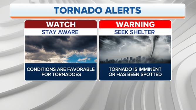
The difference between a Tornado Watch and a Tornado Warning.
(FOX Forecast Center / FOX Weather)