Amazon is promising to deliver goods with drones. Seeing these prospective innovations in airborne delivery, we’ll be forgiven for thinking that bad roads will increasingly be secondary concerns.
But the reality is that “last mile” road access will continue to be a major and costly development challenge for years to come. “Last mile" access refers to road to final destinations, whether communities, crops, markets, schools or clinics. These are typically provincial, city-municipal and barangay (village) roads in the Philippines.
Often the responsibility of local governments, these roads determine the ease and cost by which people and goods can get to final destinations. Communities across the globe face poor road access, depriving them of economic and social opportunities, whether bringing produce to markets, getting kids to school, or mothers to clinics. Billions of dollars continue to be spent on last mile road access, but often with very poor results.
Can drone technology make a difference?
In the Philippines, many roads remain unpaved, disconnected, and impassable. Low cost geo-tagging technology are being used to collect thousands of road project images and videos with smart phones across the archipelago. The World Bank-supported Philippines Rural Development Program mandates and discloses geo-tagged tracks and associated pictures. The new Kalsada program, which means “road” in Filipino, provides national financing, but includes a performance criteria for the submission of road videos, or Routeshoots, to the on-line OpenRoads portal before, during, and after the project start.
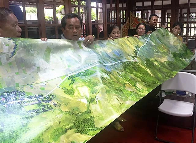
Drones are also being used to hone in on priority projects, ideally serving as focal points for more informed and participatory local infrastructure prioritization.
Back to basics: Mapping for prioritization
Basic maps are a precondition to better participatory road prioritization. Nevertheless, there is no widely available reference map for municipalities to support the prioritization process of local governments. Progressive local leaders have turned to OpenStreetMaps (OSM), the Wikipedia of maps powered by 2.2 million users worldwide, and pursued targeted drone tracking to document road needs and investment progress. When a community is mapped, OSM not only provides a good picture of the roads, but also serves as a jump off point to get more information about road segments, and work needed for unmapped roads.
Making road financing requests more transparent and systemic should see local governments not only document individual projects, but provide a comprehensive and open, digital picture of their road networks and investment priorities. Working with four pilot localities, the Bank combined a challenge for comprehensive community-based mapping on OpenStreetMap with drone documentation of priority road projects. This galvanized interest in mapping more broadly, and had the local governments work effectively with local start-up organizations such as Map The Philippines and Skyeye, Inc. to identify local connectivity priorities.
Getting concrete: Maximizing impact of drones
While drones have the potential to provide unprecedented amounts of information, scaling up real impact will require showing tangible, practical use and effectively exploiting the emerging technology as its cost declines. It should be kept in mind, however, that drones, like satellites, are only channels for data, and are not a substitute for good planning, budgeting and supervision of road construction, reinforced by strong local stakeholder engagement.
Improvement of procurement guidelines for drones
The growing demand for drones in the Philippines has stimulated a cottage industry for drone mappers. As national and local governments consider the use of drones, model terms of reference that clarify novel issues such as licensing, intellectual property, standards and technical analysis is essential to set expectations between the parties. Proper country certification also needs to be considered.
Drones provide valuable data, but the information gathered must still be processed, managed, and analyzed to increase their value. Drone images are analyzed to assess whether roads meet technical specifications, and validate whether contracts are properly implemented. Geoprocessing can help extract information such as road widths and integrity. Such information will prove useful for public infrastructure analysis, and will make for more responsive public investment decisions around the country’s road network.
Improvement of access to drone mapping
To maximize the utility of data, the government must find ways to store images and share these to the public. Cloud-based and predominantly open source platforms provide highly scalable and cost-effective platforms across national and local governments. Philippines OpenRoads has also allowed to bringing together sky and ground based image and video capture. As storage becomes increasingly cheap, this is no longer a constraint for more openly sharing and combining rich digital information. Drone imagery captured for the four pilot localities is now shared on OpenAerialMap.org, a free collection of openly licensed satellite and drone imagery.
Drones are helping local governments prioritize how to address the last mile challenge to better reach underserved Filipinos.
Are you already using drones or satellite imagery in your projects? Please share your ideas and examples to build up our understanding of how such tools can strengthen governance and promote results on the ground.
Tweet these:
Drones for Better Roads: Pointers from the Philippines.
Drones help local governments better reach under-served Filipinos.
"Last mile" access refers to a road's, often provincial, final destination.
Drones can show if road contracts were properly executed and if technical specifications were met.

Join the Conversation