
City launches web map to assist residents
By Alejandra Pulido-Guzman - Lethbridge Herald on January 10, 2024.
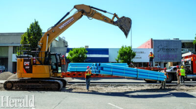 Herald file photo - Crews begin work on the 7 Street project this summer downtown. The City has launched an interactive map with information regarding road closures, facilities, city projects and initiatives.
LETHBRIDGE HERALDapulido@lethbridgeherald.com
The City of Lethbridge has launched an interactive map for residents to gain access to information regarding road closures, facilities, city projects and initiatives at their fingertips.
City of Lethbridge’s 311 business integration manager Mike Wilk spoke to reporters Tuesday afternoon about the City’s Project Webmap and said this is something that has been utilized for couple of years, and is now ready to be shared with the public.
“Working with our IT department and our communications team, we were able to make some tweaks to the map so we could publish it live, so that residents can have a self-serve option to look for project information,” said Wilk.
 He said the webmap, being a self-serve option, helps residents access project information without having to call 311.
 “Our goal is to provide residents with a tool to independently navigate and discover the various projects in our community and we believe that the webmap does just that,” said Wilk. Â
He said even though the City is hoping the web map deflects some calls, residents are still welcome to call 311, but this provides them with another option to find information.
“This (web map) is updated daily either by a 311 team or the project managing group that is managing a particular project,” said Wilk.
He said the updates will be figured out on a project-to-project basis because not all projects are the same and since most are weather dependent, updates will have to be tailored to each individual one.
“We’ll have to try and figure out how best to update that, but typically if they do hit a certain milestone, we will look to update that in the project map and have that information available,” said Wilk.
 He said the City will also include updates about changes to completion deadlines if they change.
 “The information that’s input into the map is manual, so that means it’s done by a person that gets information from someone else, so we’re as good as the information we get. That will be our challenge, to make sure that the map is updated as good as it can be, and that the information is accurate as possible for residents,” said Wilk.
 The webmap can be found at http://www.lethbridge.ca/roadclosures and residents are encouraged to check out the map, and offer suggestions or comments by calling or chatting with 311.
14-13
